Hiking and nature
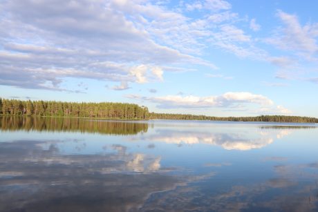
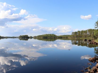
Lestijärvi has hundreds of kilometres of nature trails in varying sceneries, which provides you with an amazing opportunity to explore the forests, swamps, wilderness, lakes, river and much more. There are trails suited for both beginners and experienced hikers. On this page you will find information and locations of the recommended hiking trails and nature walks you can explore around Lestijärvi.
While hiking in the nature, we remind you to follow the Outdoor Etiquette and check the forest and grass fire warnings.
Remember to
1. Respect nature – leave no trace in it. Keep your pets on a leash.
2. Mainly use marked trails and follow the rules for different modes of travel. Check the areas and times in which access is possibly restricted at your destination.
3. Camp only where it is allowed. Do not wash the dishes or yourself directly in a water body. Follow the rules of wilderness huts.
4. Light your campfire only where it is allowed and use a camping stove where possible. Do not light a fire when a forest or grass fire warning is in effect.
5. Do not litter.
If you are planning to go explore the nature, check also the everymans right, which tells you what you are and aren´t allowed to do and pick in the wild.
Safe and enjoyable nature experiences!
Peuran polku – Deer´s trail
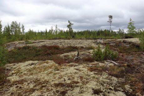
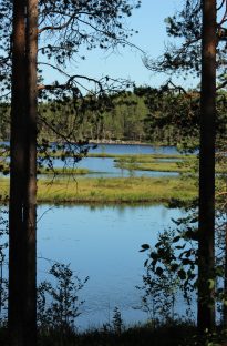
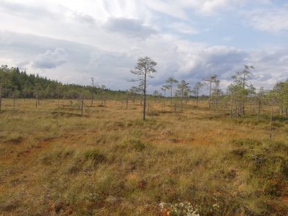
Peuran polku is a 115 kilometres long nature trail network that runs through Lestijärvi, four other municipalities and the Salamajärvi national park. The trail also covers Central and North Ostrobothnia as well as Central Finland. The most common views along the uninhabited wilderness trail are rough swamps, old forests and lakes and ponds.
It is easy to go for a day trip to Peuran polku trail as the huts and beautiful spots on the way are not far from each other nor are they far from the town centre of Lestijärvi. A good starting point for hikes is Valkeinen.
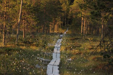
Peuran polku trail is also perfect for a multiday hike and many people from all parts of Finland travel here to explore the trail. There are various huts and fireplaces along the way, where you can stop to rest, have a meal or spend the night. The trail consists of many different trails. The main trail is 77 km long and is only suited for experienced hikers who are able to orienteer. However, the trail can be spit to parts, when it is suitable for beginners too.
The trail can be used during non-snow periods because in the winter the markings on the trees can be covered in snow. The trails will also be snowy and cannot be used without skis or snowshoes.
Find more information on Peuran polku trail here and get the map of Peuran polku trail from the library of Lestijärvi.
Recommended starting/ending point in Lestijärvi for the Peuran polku trail is Valkeinen.
Google maps locations for the starting/ending points
Map of Peuran polku
Valkeinen
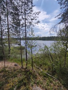
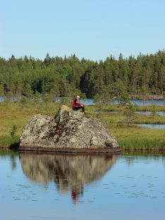
The clear watered lake Valkeinen has a circle trail going around it. The trail is about 5,5 kilometres long and in the middle of it there is the Pökkelöniemi hut, where you can have a break. The difficulty level of this trail is easy, so the trail can be enjoyed by the whole family. If you prefer to take a longer hike in the trails, you can continue your journey from the lake Valkeinen all the way to Salamajärvi national park in Kinnula or head towards Reisjärvi, as the trail is part of the Peuran polku trail network. The circle trail is only one of the many activities you can enjoy while visiting Valkeinen.
Valkeisjärven leirintäalueoffers activities like minigolf, frisbeegolf and rental boats for fishing. They also have different types of traditional Finnish saunas and a hot tub and the restaurant serves all kinds of foods, snacks and desserts. If you wish, you can also rent a cottage by the lake to spend more time by the spectacular lake Valkeinen. Next to Valkeisjärven leirintäalue there is Riistaravintola Pikku Peura,which is a catering-restaurant. You can reserve the restaurant for birthdays, weddings and other celebrations and the food will be delivered. Notice that Riistaravintola Pikku Peura is only open by recervation.
Directions
Valkeinen is located 15 kilometres from the town centre of Lestijärvi towards Kinnula. The lake is seen from the road and there is a sign by the road to guide you to either Valkeisjärven leirintäalue or Riistaravintola Pikku Peura.
Iso-Ruonanen
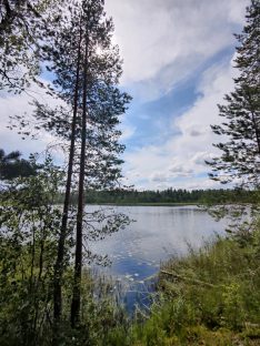
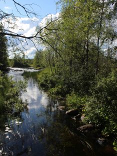
Iso-Ruonanen is a lake by the hiking trail Peuran polku. It is the next lake you will reach if you start your hike from lake Valkeinen. Iso-Ruonanen is a long but narrow lake, which gives you the opportunity to hike along side it. When you reach approximately the middle point of the lake, you can stop for a break as there is a table by the trail.
Jatkonjärvi
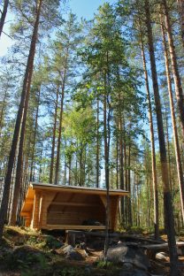
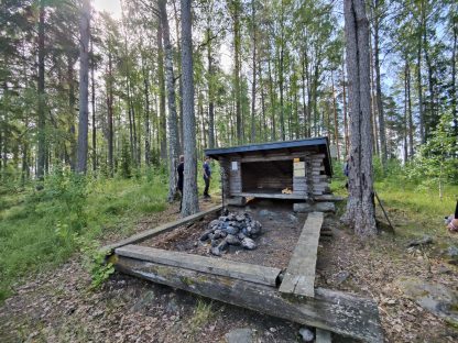
You can walk the trail from Valkeinen to lake Jatkonjärvi, when the length of the route is about 6 kilometres. Lake Jatkonjärvi is a magnificent wilderness lake that will charm anyone who visits it. There is also a newly built lean-to shelter by the lake where you can have a break between hikes and a fireplace for cooking. There is also a firewood shed and toilet facilities. This trail passes by big rock formations and other lakes before arriving to Jatkonjärvi. The gorgeous scenery on the way and the great stopping point waiting at the end make the hike worth of the effort.
Directions
It´s possible to hike from Valkeinen to Jatkonjärvi, which is about 6 kilometres long route or you can drive closer to Jatkonjärvi if you wish to make a shorter trip. If you prefer to drive, you can drive forwards on the border road of Lestijärvi and Kinnula until the sign points to Porraslammintie which turns right. Drive until you reach the path that leads to Jatkonjärvi. You can see the starting point of the path in Google Maps link below.
Lehtosenjärvi
Lehtosenjärvi is a charming wilderness lake by the Peuran polku trail. The high-quality hut and the well-maintained nature trails of Lehtosenjärvi are suitable for both a day trip and a longer hike as Lehtosenjärvi is part of Hirvaankierros, which is a 58km long circle trail connected to Peuran polku trail. On the route, you can explore old forests and swamps and admire the lake views.
Lehtosenjärvi is a part of the 115 kilometres long nature trail network of Peuran Polku and is therefore easy to hike and reachable from multiple destinations. You can make your own route by combining the different spots along the well-marked Peuran polku trail or go for a day trip. The easiest way to get to Lehtosenjärvi from Lestijärvi, is to drive the border road of Lestijärvi and Kinnula until you get to the parking spot of Lehtosenjärvi. You can also find the map of the Peuran polku trail from the parking spot.
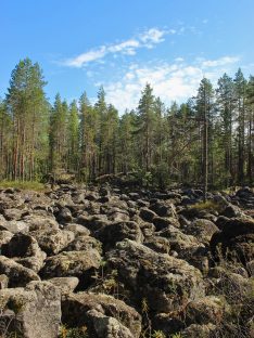
While hiking, you can see amazing views including old spruce forests, swamp views and the lake itself as well as some rock formations that are a proof that the area used to be in the bottom of the sea. Next to the trail you can find countless berries like blueberries, cloudberries and lingonberries, and also many species of mushrooms you can pick freely with the everymans right.
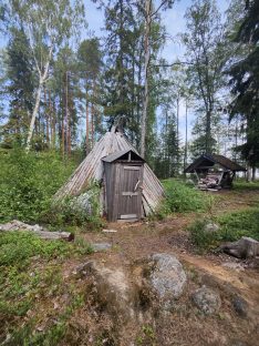
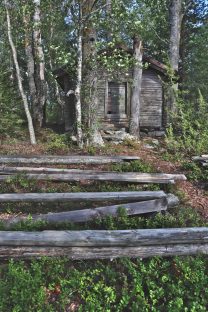
The hut of Lehtosenjärvi is well-equipped and very spacious. The hut has a pot for making coffee and you can dry your clothes on the washing line if they got wet during the hike. There is also an outdoor toilet and a fire shed by the hut.
Directions
Lehtosenjärvi is reachable from the border road of Lestijärvi and Kinnula. Drive along the road until you reach the parking spot of Lehtosenjärvi, which can be recognized from the Peuran polku map.
Vähä-Valvatti
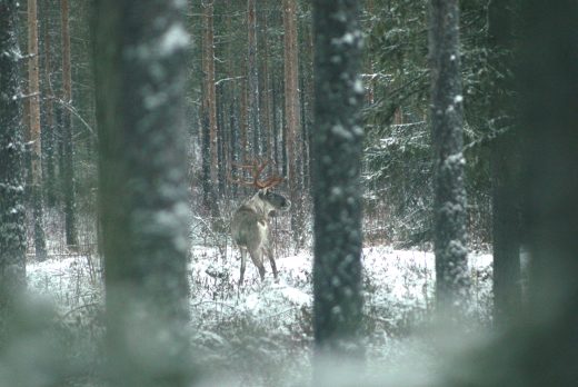
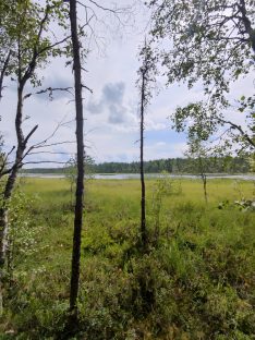
Vähä-Valvatti is a small wilderness lake on the route of Peuran polku trail. The stopping point with its shelter and fireplace is surrounded by old forest and historical rock formations made by people before our time. On the path to Vähä-Valvatti, you can admire the pretty swamp views and forests. Vähä-Valvatti area is a good spot for mushroom and berry picking, and you might even see some wildlife on your trip.
In Vähä-Valvatti there is a shelter and an outdoor fireplace for cooking as well as a table for eating. The firewood can be found in the shed and you can spend your evening by the warm fire, looking at the gorgeous scenery.
Directions
Vähä-Valvatti is reachable through Konttikoskentie. Follow the instructions by the road that says “Karhunpiilo” and once there is only 2km left to Karhunpiilo, turn to right from the intersection. The left road continues to Karhunpiilo and by following the right until the end, you will reach the a parking spot where you can leave your car while visiting Vähä-Valvatti. Underneath you can see the starting point of the trail and the location of the Vähä-Valvatti shelter.
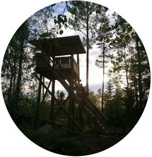
Bird watching tower of Iso-Valvatti
The bird watching tower of Iso-Valvatti is overlooking the old, dried up lake of Iso-Valvatti. The dried up, swampy lake provides the perfect living environment for various species of birds and animals and therefore is a good place for nature photography and animal watching. The scenery from the tower is spectacular and it is a nice place to stop for a coffee break on your hike. By combining the bird tower to Vähä-Valvatti and the Cottage, it makes a nice day trip, that is about 4 kilometres long. The bird watching tower is located on Perho´s side of the border but none the less, it is a popular nature destination among the people of Lestijärvi.
Directions
The bird watching tower can be reached the same way as Vähä-Valvatti by car. From the parking spot, the nature trail goes straight and then divides into two. Vähä-Valvatti goes to the right and the bird watching tower to the left.
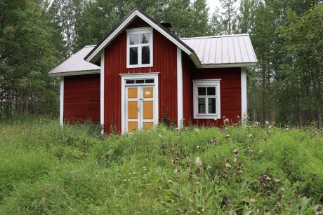
Valvatin autiotupa
Only 1,1 kilometres from the bird watching tower, is the cottage where you can freely spend your night when hiking. The cottage is a traditional Finnish styled house and serves as a sanctuary for all the hikers, hunters and fishers passing by in the wilderness. You can spend your night there without a reservation or payment if you are hiking on the Peuran polku nature trail. The cottage is located on the border of Lestijärvi and Perho but remains on the side of Perho. The cottage has 8 beds, a little kitchen, and a living room. Outside the cottage, there is a sauna, a well for drinking water and an outdoor toilet.
Directions
The cottage can be reached the same way as the bird watching tower or Vähä-Valvatti.
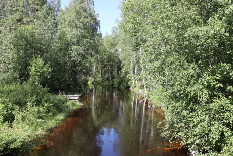
Trails and nature by the river Lestijoki
Niskankorpi
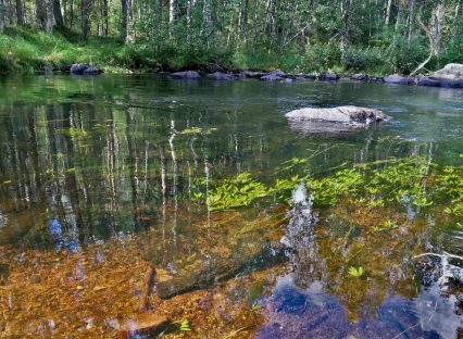
Niskankorpi is a popular fishing spot along the river Lestijoki because of the various species of highly valued, delicious fish, like salmon, grayling, and brown trout. The riverbanks are easy to walk and you can go all the way to Raivio and fish along the way if you wish. The route is also nice for just walking as there is some old spruce forest as well as varying birch and pine forests. If you walk further, you will also find multiple swamps where you can go cloudberry picking.
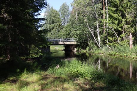
Jatkonkoski
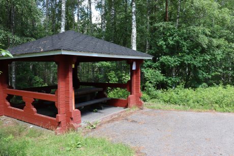
Jatkonkoski is a rapid along the Lestijoki river. There is a hut for making a fire and a table for eating. The hut is equipped with firewood which you can find in a shed next to it, so all you need to bring is the snacks and your curiosity for exploring the river area. Jatkonkoski rapid is also perfect for fishing and especially for catching salmon. The nature around it is green forests and varying swamp views not to forget the highlight of the destination, the river and its fast-flowing rapids.
Directions
Jatkonkoski nature trail is located approximately 10 kilometres from the town centre of Lestijärvi. The easiest route to Jatkonkoski is by driving towards Reisjärvi and turning left on the sign that says Niskankorventie. Drive approximately 3 kilometres until you see a parking space with the map of the trail. The
Raivio
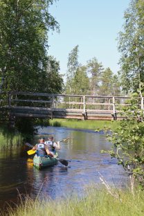
Raivio is located by the river Lestijoki and is a good spot for fishing. Raivio serves as a good base camp for many fishermen, and as a stopping point for the canoers in the river Lestijoki. The facilities include a toilet, big parking space and an outdoor fireplace for cooking.
Raivio is a popular fishing destination in Lestijärvi because of the freshwater salmon. If you do not
get lucky in Raivio, it is also easy to walk along the
river to try your luck in another spot.
Raivio is also a nice destination for nature walks as there is dense spruce forest and gorgeously green vegetation around the area. During the autumn, it is an
excellent place for picking berries and mushrooms. The canoeing route of Lestijoki goes by Raivio, which makes it a good spot for having a break in between. You can also start or end your canoeing trip from Raivio.
Iso-Valkiainen
Iso-Valkiainen nature trail is only 0,6 kilometres by foot from the parking spot, so this is the perfect place to take your kids for an outing in the nature. When you get to the wilderness lake Iso-Valkiainen, you will find a hut and an outdoor fireplace with wood in the shed. The area around the lake is gorgeous swamp scenery and it is especially beautiful during the autumn colours. There is a good chance to encounter some Finnish wildlife such as moose and various species of birds. Iso-Valkiainen is known as the place for picking cranberries in the fall and along the way you can also find some lingonberries and cloudberries, so it is well worth taking a bucket with you.
Note that all fishing is prohibited at Iso-Valkiainen at the moment.
Directions
Iso-Valkiainen is a wilderness lake located about 9 kilometres from the town centre of Lestijärvi. You can reach the parking spot by driving 7 kilometres from Lestijärvi towards Toholampi and turning right at the sign that says Raiviontie. Drive 2 kilometres and you will reach the parking spot.
Islands
Go for an island adventure and get to know the islands in lake Lestijärvi. Lestijärvi has numerous islands with lean-ins. huts and fireplaces for camping and nature trips.
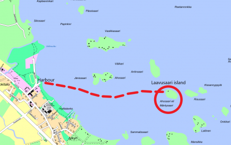
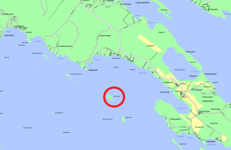
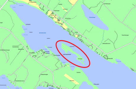
Laavusaari
Laavusaari is an island in Lestijärvi, which has good facilities for nature trips and even camping. The island has three names: Laavusaari, Mäntysaari and Ahosaari. In Laavusaari there is a lean-in, outdoor toilet facilities and a woodshed. The wood for fires is already provided. In the winter, you can ski to Laavusaari because of the ski track that is made on the ice every year. In the summer, you can reach the island by renting a boat from Kesäkahvila ja Majatalo Jukola,which is located in the boat harbor of Lestijärvi town centre.
Jussinsaari
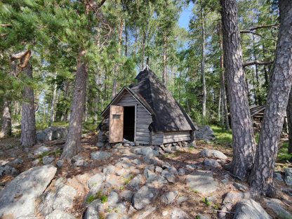
Jussinsaari is a charming insland destination, where there is large and good conditioned hut. There are also outdoor toilet facilities and a wood shed. Around the Jussinsaari island goes a nature trail. The trail´s difficulty level is medium to hard because even though the trail is short, the terrain is demanding. When visiting Jussinsaari, it is advised to park the boat by the east side of the island, where there is a berth. You can see the location of the berth from the map below.
Vasikkasaari
The narrow but long Vasikkasaari island is a gorgeous nature destination with it´s old forest and beautiful lake landscape. In Vasikkasaari there is a hut, outdoor toilet, woodshed and an extra fireplace outside. The terrain in the island is easy so you can explore the island easily.
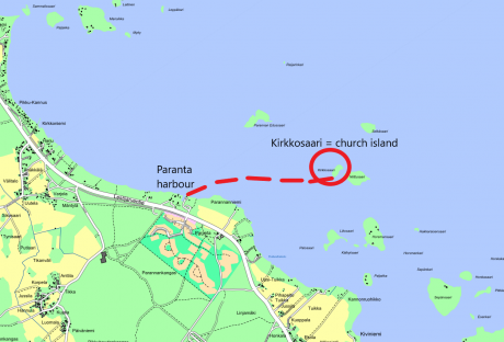
Church island – Kirkkosaari
The name of the Island comes from its use for church services, or it has been used as a temporary cemetery before moving the dead to the actual cemetery. Another explanation is that in the old days, there was a little church on the island. The most probable explanation is that the island served as a cemetery and therefore it was named after its connection with the church.
These days there is a little chapel on the island as a memorial of the previous generation´s hard work and it is a place of quiet and peace for the people moving in the waters nowadays. The chapel was a donation from Pentti and Väinö Laakso. In front of the chapel, there are benches and a wooden cross. In the chapel, there is an altar piece that says: “Tämä on varmaan Jumalan asuinsija ja itse taivaan portti. 1 Moos. 28” which means:” This must be God´s home and the gate to heaven. “
Church island welcomes both locals and visitors to stop and take a break from the busy world.
History of the church island
Historical findings have been made on the church island. There are five holes that refer to the Bronze or Iron Age and to animal hunting and processing in those eras, but the island has not been further examined to determine the age or purpose of the holes. A well preserved, ball shaped mallet has been found from the island and it can be traced back 7000 years, all the way to the Mesolithic Period. This mallet´s purpose in history has remained unclear in all of Finland but it is suspected that they have been used in hunting seals or as additional weight when breaking the ice of the lake.
Other trails and destinations
Pomokallio
The nature trail, that was established in 2019, is perfect for children. The new nature trail with its information boards is a great way for children and adults to learn about forestry, animals, plants, mushrooms, trees and much more. Spend a fun family day exercising and learning.
The nature trail has 20 information boards that will educate you on the most common types of birds and trees in Lestijärvi and has valuable information on forestry and its importance for Lestijärvi. The trail is especially suited for school field trips but there are also interesting attractions along the way for adults. The ancient erratic block and the tar pit (tervahauta) are interesting pieces of the history.
There is also the possibility for orienteering by the nature trail. There are 20 checkpoints that are in use through out the year and during summer, there are in total 40 changing checkpoints. You can find the contact details and the maps for orienteering from kepsu.sporttisaitti.com.
The map costs 5€
Directions
The nature trail of Pomokallio can be reached by driving along Itälahdentie for
about 4 kilometres until you see a sign on your left, that says Riemuhiekantie.
Turn left and drive all the way to the end, until you see the lake.